The Tiree Survey is an archaeological field investigation of settlement evidence on the island of Tiree undertaken by the Association of Certificated Field Archaeologists in partnership with John Holliday and An Iodhlann historical centre. The survey began in 2016 and to date has examined visible remains on the machair notably at Hough, as well as a group of 19th century buildings at Kilkenneth and a dwelling on a strip of improved, peripheral land at Loch Dubh a Gharaidh Fail between Balephetrish and Vaul. Work is currently concentrated on the slopes of Hynish located towards the south-western part of the island.
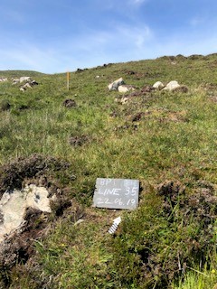
The Hynish landscape is characterised by mixtures of heather, rough grasses, outcrops of gneiss and peaty bog at the foot of south-east facing slopes. There is limited improved land to the east and north which contrasts with dramatic cliffs and gullies to the south. A survey of this varied landscape has revealed a picture of intense activity from prehistoric to modern times with 430 features recorded to date. Those putatively identified as prehistoric include several cairns, kerbed mounds and hut circles. There is also later evidence of houses and enclosures, huts, and features associated with pastoral activity such as lambing and calving. Significantly, the survey has identified 1000 lines of boundaries including single stones, combinations of stone and turf and a long post-improvement dyke. A large 19th century fank almost certainly incorporated re-used stone from earlier boundaries.
Due to the complexity of this picture on Hynish we concluded that it would not be possible to interpret settlement evidence detached from boundary lines. The key aim of this current survey is to produce a map combining boundary data and settlement evidence in terms of their relative positions in the landscape and to posit associations between the two. The hope is that the survey will identify overlying boundaries providing an opportunity to suggest earlier and later activity. To date, this is the case in ten instances.
The Hynish Boundary Survey presents several challenges for an amateur archaeological society skilled in field survey and manpower rich but with limited access to funding and equipment. This initial report is a ‘warts and all’ glimpse of progress to date and is intended not only to update members of the Association but also to be of interest to others, in particular similar amateur societies and community groups. It shows our workings, so to speak – our mistakes, challenges, limitations and, we hope, successes.
Elaine Black, co-Director
Report authors, Ailsa Smith and Edward Smith

