Glen Lochay survey dates for March to June have been announced. They are: March 23, March 30, April 6, April 13, May 4, and May 11. All dates are Sundays. A camping weekend is also planned. More details can be found in the Members’ Area.
Author: Acfa Editor
Achnahannait


An Riol


An Riol
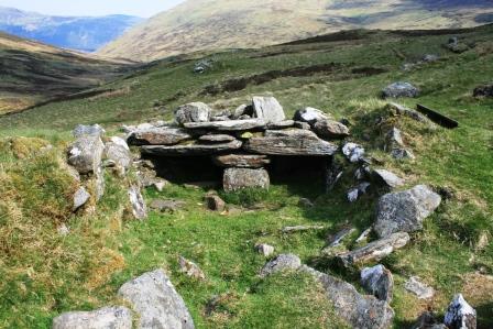
The shieling grounds of An Riol lie southwest of Ben Lawers, west of Lochan na Lairige and north and northwest of the Tarmachan Ridge. The site is a huge amphitheatre which measures over 2kms north-south and around 1.50kms east-west. Archives found within the Breadalbane Muniments record that An Riol has been leased for shieling since the early 15th Century and it may have existed before this. Fortunately the archives give a useful insight into how the shieling grounds were leased and used.
The survey, which involved almost 30 ACFA volunteers, was carried out over 3 weekends in 2008 and 2009. The report was published as ACFA Occasional Paper No 103 in 2010. During the survey just under 300 features were recorded, comprising enclosures (including a well-preserved poindfold), dairy stores, byres and shieling huts. Some of the remains are seen now as faint circular banks under the grass but some are clearly much later and are rectangular stone structures standing in some cases to 5 or 6 courses.
The record tells us that by the second half of the 18th Century the shielings were being used for grazing beef cattle and sheep and by 1821 the lease was taken away from the surrounding townships and given to 1 sheep farmer from the north of England who ran it as an enormous sheep run.
Nowadays there continue to be a few sheep grazed here in the summer and some shooting and stalking takes place in the autumn. This beautiful and evocative site is well worth a visit and is easily accessible from the un-numbered road which goes between North Loch Tayside and Bridge of Balgie which runs right through the shieling grounds – easy for most of the year but not for the faint-hearted in winter.
Survey Director – Anne Macdonald
Achnahannaid
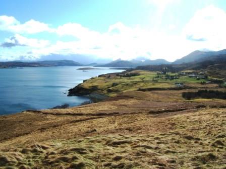 Achnahannaid lies on the east coast of Skye on the road down to Braes. The survey was carried out in 2012 by some twenty ACFA volunteers.
The purpose was to determine whether there was any ecclesiastical connection with the township, as its name means the Field of the Church or perhaps the Field belonging to the Church. The church was possibly St Moluag’s which lies across the Sound on the Isle of Raasay.
Sadly no evidence either in the records or on the ground could be found to substantiate this theory.
The township, which appears on Blaeu’s map of 1640, was altered in 1810 by Lord Macdonald and laid out as eight crofts with an area of common grazing. It remains as such to the present day although only one man now crofts the township.
The survey using an EDM, produced an overall 1:1000 map of the area. Drawings of the individual structures were drawn at 1:100. Photographs were taken and detailed descriptions of the individual features were produced. Most of the structures were from 1810 onwards with the exception of a few remains lying in the common grazing. Some ninety features were recorded.
In addition to the field survey an extensive study was carried out in the various archives as to who owned which croft and when.
The findings were published as ACFA Occasional Paper No 121 in 2013.
Survey Directors John Macdonald & J. Scott Wood